
As we’re all aware, there are a number of tracks that traverse the Simpson Desert. The most popular track is the French Line. This track takes the most direct route across the desert and as a result is the shortest.
Being the most popular track means it can also be the roughest due to more traffic. This also means more potential of being stuck behind other drivers, and an increased number of vehicles coming the other direction.
We’ve been thinking through the idea of possibly taking the WAA line across the desert for a number of reasons which are:
- less traffic on the track
- potentially smoother driving conditions
- slightly better fuel economy, and
- quite likely a bit more to see
This thought process was backed up by my ex work mate the other day who indicated that the WAA line was potentially still clay capped in places which would mean lower fuel consumption and a smoother ride.
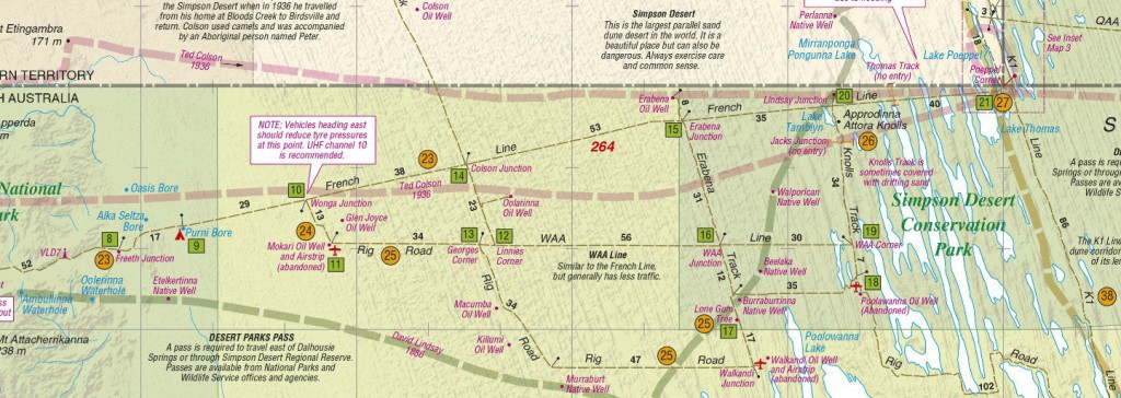
Taking the WAA line also means that we have a section known as the Knolls track to follow to make it back to the French Line. This track travels between the dues for quite a way which would not only be better for fuel economy but would also show the different ‘swale’ scenery. There is also the Knolls that the track is named after which are large rocky mounds that are really the only geographical feature in the desert other than the dunes.
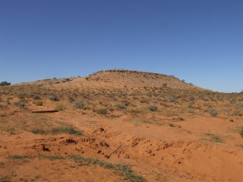
The other feature that is within reach from the WAA line is know as the Lone Gum. This is a camp site beside a gum tree growing, on it’s own, in the middle of the desert. This is about 20k’s off the track so seeing it would use extra fuel, however if fuel levels are on our side it is a possibility.
 Taking this side trip would see us venturing onto the Rig Road, back to the Knolls track, so it would in effect see us travelling on the French Line, the WAA Line, the Erabena Track, the Rig Road and the QAA Line by the time we get to Birdsville.
The obvious down side of taking some or all of this route is the additional distances to travel, specifically an additional 40 to 80 kilometres. This generally won’t be an issue for diesel vehicles, but could certainly be a challenge for petrol models.
However we need to remember that the additional k’s will likely be more economical as the majority of these extra k’s are to be traveled in the swale, between dunes, instead of crossing the dunes.
At this stage we’re thinking the best approach would be to plan for some or all of this as an option, eg, make sure fuel storage can accommodate this route, and then make the actual decision when we get to Mt Dare.
Local knowledge will be crucial in making this decision as the Mt Dare station owners and other travelers passing through will have the best idea of what all the road conditions are like.
Weather conditions leading up to our arrival may rule out the WAA line completely, however its great to have options.
Cheers, Kent.